bool(false)

MountainsMap®  –
3D analysis software for evaluating measurement data

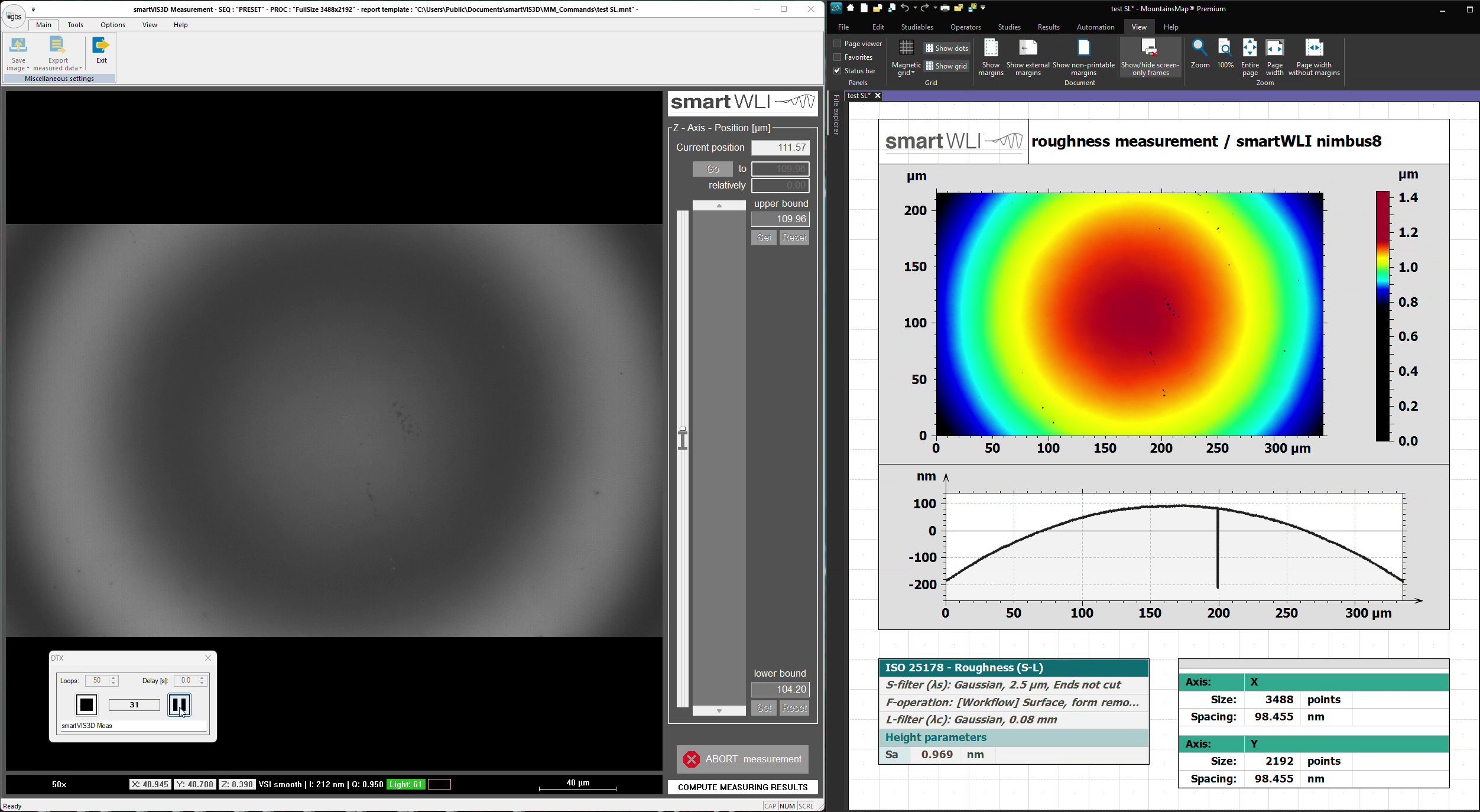
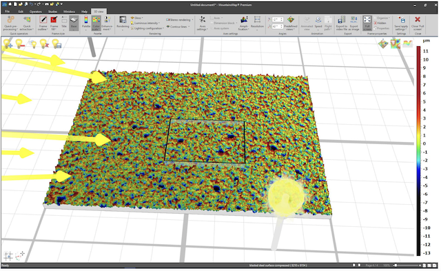
With MountainsMap®, you can evaluate 3D measurement data from your smartWLI surface metrology quickly, in compliance with standards, and with visually compelling results. The software is a universal tool for visualizing, analyzing, and documenting measurement data – from contour analysis to ISO-compliant roughness evaluation.

Logo of the MountainsMap Analysis software

MountainsMap® Imaging Topography

Basic module Basic module for displaying and evaluating 3D data and required for the use of all optional modules
Workflow interactive macro creation
Selection of macros in smartVIS3D for automated measurement and evaluation processes
Results form the basis for further interactive assessments
Functionality Automated visualization and evaluation of 3D data, including topography, image data, and quality information
Merging of individual measurements using positioning data and/or overlapping areas
Selection and evaluation of profile sections
Selection and evaluation of profile sectionsCalculation of 2D and 3D roughness parameters and basic functions for the evaluation of microgeometries
Batch process analysis of many 3D data sets
Excellent teamwork

Seamless collaboration with smartVIS3D

MountainsMap® perfectly complements the scanning software smartVIS3D. After completing the scanning process, MountainsMap® automatically takes over the evaluation of the acquired data. Predefined macros enable application-specific assessments and ensure reproducible results with minimal time investment.

With predefined macros, application-specific evaluations can be performed quickly and reproducibly – ideal for efficient workflows.

Efficient resource management and shared data processing with smartVIS3D enable double throughput, ensuring optimal resource utilization.

Screenshots Collaboration between MountainsMap and SmartVIS3D
Universal software package

Powerful features for maximum impact

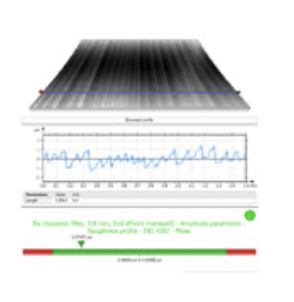
  • Contour analysis & profile evaluation
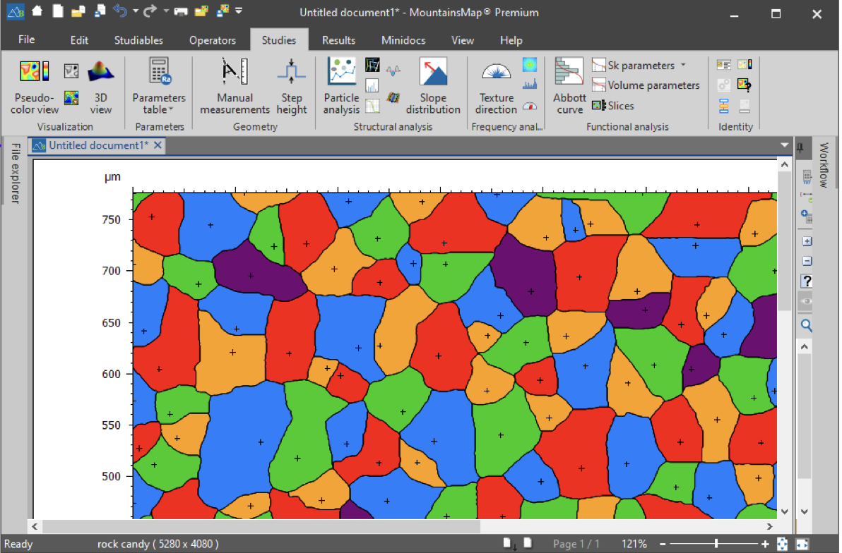
  • Statistical particle and structure analysis

  • Geometric measurement data & tolerance verification

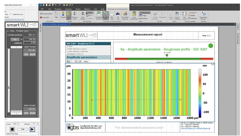
  • ISO-compliant 2D and 3D roughness analysis

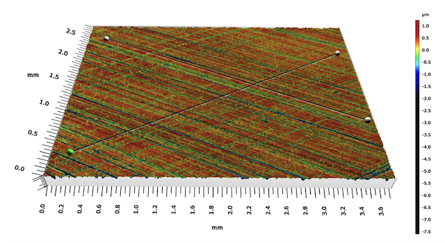
  • 3D data alignment and comparison (e.g., CAD models, before/after measurements)

  • Filtering & stitching/patching to combine large measurement areas

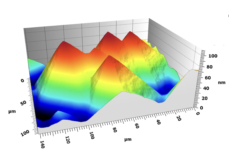
  • Versatile visualization options (2D/3D views, contour lines, color palettes, animations, stereo rendering)

Screenshot MountainsMap user interface
Application example MountainsMap
Imaging Topography

Visualization options

  • 2D and 3D display
  • Contour lines and diverse color palettes

  • Various lighting models, specular highlights, and stereo rendering

  • Animated surface movements and export of animations


Profile extraction:

  • Interactive selection of one or multiple profile lines

  • 2D and 3D display of profile lines

  • Automatic updating of subsequent results

Screenshot MountainsMap Profile Extraction
Screenshot MountainsMap Profile Visualization

Individual workflows and automation

MountainsMap® works on a document-based system and allows you to customize each processing path individually and save it as a template. Raw data remains unchanged and can be replaced at any time—ideal for validating the same processing pipeline with different input data. New in version 8 is simultaneous data processing:

Multiple datasets can be processed simultaneously, significantly increasing throughput. For recurring tasks, batch processing is available, allowing saved templates to be applied to any number of datasets. Results and reports can be conveniently exported as PDF, Excel, or in other formats.

Screenshot MountainsMap - individual workflows
Screenshot measurement software -MountainsMap
Modular structure

Software packages and application areas

MountainsMap® is modular and can be precisely tailored to the specific task. Besides the base package, numerous extension modules are available.

This flexibility makes the software an ideal tool for a wide range of applications:

  • Topographic analysis of micro- and nanostructures

  • Statistical evaluation of porosity or honeycomb structures

  • Wear and structural analyses in research and quality control

  • Comparison of measurement data with CAD models

Whether you analyze surfaces in the automotive industry, medical technology, or precision manufacturing — you select exactly the modules you need, and MountainsMap® grows with your projects as required.

Screenshot MountainsMap user interface

Automotive

  • Optional module: extends the functionality of MountainsMap® Imaging Topography
  • Functionality extension: calculation of functional parameters for the automotive industry

Advanced Profile

  • Optional module: extends the functionality of MountainsMap® Imaging Topography
  • Functionality extension: advanced filtering options for spectral and fractal analysis of profiles
  • Statistical analysis of profiles
Logo MountainsMap Automotive
Logo MountainsMap® Advanced Profile

Contour

  • Optional module: extends the functionality of MountainsMap® Imaging Topography
  • Functionality extension: dimensional analysis of profiles and contours

Advanced Contour

  • Optional module: extends the functionality of MountainsMap® Imaging Topography
  • Includes MM 2005
  • Functionality extension: advanced dimensional evaluation options for profiles and contours
  • Import of dxf files and comparison with CAD data

Advanced Topography

  • Optional module: extends the functionality of MountainsMap® Imaging Topography
  • Functionality extension: advanced filter functions
  • Volume, spatial, hybrid, and flatness parameters, isotropy and periodicity evaluations, peak evaluation, and fractal evaluations
Logo MountainsMap® Contour
Logo MountainsMap® Advanced Topography

Fourier and Wavelets

  • Optional module: extends the functionality of MountainsMap® Imaging Topography
  • Functionality extension: FFT-based spectral analysis options
  • Wavelet, spectral, and multiscale analysis of surface textures

Colocalization

  • Optional module: extends the functionality of MountainsMap® Imaging Topography
  • Functionality extension: alignment of data sets with large overlapping but non-identical measurement positions
Logo MountainsMap® Fourier Wavelets
MountainsMap® Fourier Wavelets

4D Series

  • Optional module: extends the functionality of MountainsMap® Imaging Topography
  • Functionality extension: visualization of surface changes (timelines) from measurement series of the same measurement object

Particle analysis

  • Optional module: extends the functionality of MountainsMap® Imaging Topography
  • Functionality extension: detection and classification of local surface structures can be used for particles, pores, grains, peaks, etc.
  • Threshold, watershed, edge, and spherical detection of surface structures
  • Classification of volume, area, height, depth, position, distance, shape, and orientation…
Logo MountainsMap® 4D-Series
Logo MountainsMap® Particle Analysis

Scale Sensitive Analysis

  • Optional module: extends the functionality of MountainsMap® Imaging Topography
  • Functionality extension: method for analyzing geometric properties of surface textures and their scale derivatives (complexities), including length scale and area scale method

Lens Analysis

  • Optional module: extends the functionality of MountainsMap® Imaging Topography
  • Functionality extension: methods for evaluating aspheric surfaces and profiles
Logo MountainsMap® Scale sensitive analysis
Logo MountainsMap® Lens analysis

MountainsMap module Thickness Analysis MM 2016

  • Optional module: extends the functionality of MountainsMap® Imaging Topography
  • Functionality extension: methods for evaluating the layer thickness of multi-layer data sets

MountainsMap Addon honing structure analysis AO 1001

  • Methods for analyzing geometric surface properties of cylinder bores
  • Results: Honing angle, ascending/descending grooves, ascending/descending structures, cross/closed structures
  • Software module for MountainsMap® Imaging Topography, requires MountainsMap® modules Fourier and Wavelets
MountainsMap® Thickness analysis
Logo MountainsMap® Honing structure analysis
Vorteile von MountainsMap

Your benefits at a glance

With MountainsMap®, you get a professional, standards-compliant analysis platform that integrates seamlessly into your measurement processes. Benefit from shorter analysis times, less manual rework, and clear visualization for documentation, reporting, and customer communication.

shorter analysis times

less manual rework

clear visualization for documentation, reports & customer communication

Application example MountainsMap
30-day free trial

Try the free trial and sample measurement now

01

Download

MountainsMap® is available as a 30-day free trial download from the website www.digitalsurf.com.

GBS offers the first test measurement generally free of charge!

You can test MountainsMap using the data from your sample!

02

Configuration

Test your configuration to determine the necessary evaluation modules!

The trial version can be configured with or without add-on modules.

This way, you avoid unnecessary costs.

Trial periods are available anytime – even if you have already purchased the base package and are considering a software upgrade.

03

Contact

If you have any questions about the MountainsMap® trial version, please feel free to contact us anytime:

sales@gbs-metrology.com

more from GBS

Recommended Products

smartVIS3D

Fast measurement software for calculating high-resolution 3D data
Accessories Example configuration:
bool(false)

smartVIS3D – system software

With smartVIS3D, you experience the perfect combination of state-of-the-art 3D surface measurement technology and powerful software. The system software enables intuitive handling, real-time processing of high-resolution 3D data, and efficient control of your measurement device – for reproducible and reliable results.

Screenshot smartVIS3D
graphical user interface
visualization camera image, intensity adjustment, contrast enhancement
parameter control scanning range, increments, evaluation macros, ROI, decimation
Resolution High-resolution 3D data
evaluation algorithms
VSI vertical scanning interferometry
EPSI extended phase shift interferometry
GPGPU real time evaluation of 3d data on programable graphic boards
infinite focus optional generation of an infinite focus camera layer elimination of interference fringes
data quality surveillance
functionality use and exports optional data quality information based on correspondence of the registered signal with an ideal interference signal (correlogram) for each measuring point all 3d point undergo an additional plausibility check
control of motorized stages
positioning movement control
stitching macro generation for multiple scans and stitching automated measurements of multiple positions or stitching areas

Intuitive control and automated workflows

With smartVIS3D, you control the measurement system effortlessly – from sample positioning to data acquisition:

  • Selection of the measurement volume in X, Y, and Z

  • Configuration of measurement parameters such as objective, illumination, and speed

  • Support for EPSI/VSI for highest Z-resolution

  • Selection of evaluation scope via MountainsMap macros

smartVIS3D is ideally suited for:

  • High-precision surface measurements in research and development

  • Quality assurance in the production of lenses, glass, and microstructures

  • Analysis of steep, transparent, or rough surfaces

Screenshot Automation smartVIS3D

High-speed measurements with maximum precision

smartVIS3D delivers massive computing power with over 80 TFLOPS across more than 16,000 cores, enabling real-time processing of high-resolution 3D data.

  • Up to 8 million data points per capture

  • Up to 3,000 images per second

  • Vertical scanning speeds of up to 400 µm/s

  • Up to 75,000 images per measurement

  • Supports up to 450 GB of image data

Thanks to real-time GPU-based processing, you receive 3D data without delay – even for complex and steeply inclined surfaces.

Photo of a graphics card for parallel image processing
smartVIS3D - Monitoring data quality 3D

Intelligent image processing
for precise results

Our software offers advanced algorithms for image correction, contrast optimization, and flexible measurement control—developed for maximum measurement accuracy even with challenging samples:

  • Customizable measurement range for individual requirements
  • Reliable measurement of transparent and steeply inclined surfaces
  • Smooth, artifact-free edges thanks to model-based signal processing
  • Automatic outlier detection for maximum lateral resolution
  • Dynamic lighting and contrast adjustment for easy positioning and reliable detection
  • Selective removal of unwanted scan areas
SmartVIS3D - contrast enhancements

Highest height resolution with Extended Phase-Shift Interferometry (EPSI)

For applications requiring maximum precision, our system with Extended Phase-Shift Interferometry (EPSI) offers Z resolution in the sub-nanometer range – ideal for extremely smooth and optically polished surfaces.

EPSI uses precise phase evaluation within the interference signals and extends classic methods with finely tuned phase shifts at a high vertical sampling rate. In combination with model-based signal processing and GPU-accelerated evaluation, EPSI enables reliable detection of the finest height differences – even with minimal contrast or weak reflection

Your advantages:

  • Sub-nanometer Z resolution for ultra-precise surface analysis
  • Optimized for reflective, smooth, and functionally coated materials
  • Stable against environmental noise thanks to highly dynamic signal evaluation
  • Ideal for applications in optics, semiconductor manufacturing, micromechanics, and research

Powerful data analysis with MountainsMap®

For precise and user-friendly evaluation of your 3D measurement data, smartVIS3D is fully integrated into the MountainsMap® analysis platform—the globally established software solution for surface metrology.

The seamless connection enables direct further processing of interferometry measurements from smartVIS3D—from visualization to in-depth analysis.

Your analysis advantages with MountainsMap®:

  • Intuitive 3D visualization of surface structures and profile sections
  • Roughness and waviness evaluation according to international standards (ISO, DIN, JIS, etc.)
  • Form inspection and statistical structural analysis of complex functional surfaces
  • Tolerance comparisons with user-defined or standard-based limit values
  • Automated evaluation of large measurement series via macros and batch processing
  • Data export in numerous formats for documentation, further processing, or reporting (e.g., PDF, Excel, CAD)

Customizable and powerful: Whether for research, quality assurance, or series testing, MountainsMap® is the ideal complement to smartVIS3D for all applications where surface function matters.

smartVIS3D - Mountains Map
Screenshot measurement software -MountainsMap
smartVIS3D SDK

smartVIS3D DLL for integrators

functionality library to control all sensor functions from a third-party software in contrary to the standard smartVIS3D is no GUI included
programming languages C++; C#
documentation handbook source code of an example application for instant success and test of sensor functions
INTELLIGENT UPGRADES FOR MAXIMUM PRECISION

Flexible software upgrades for smartVIS3D

Expand your smartVIS3D software with powerful upgrade modules tailored to your specific applications in quality assurance, production monitoring, or research and development. The modular extensions enable maximum functionality and precision – exactly when you need them.

Overview of available upgrade modules:

  • Extension Project Management
    Automation of complex measurement projects with multiple measurement positions, automatic focus, lens change, and optional leveling—ideal for time-consuming applications such as wafer measurements or structured substrates.
  • HD-EPSI / High Precision
    For high-precision height measurements in the sub-nanometer range – ideal for reflective, smooth, or optically polished surfaces, e.g., in semiconductor, optical, or medical technology.
  • smartStitch
    Seamless stitching of multiple individual measurements into large-area, high-resolution 3D data sets – e.g., for wafers, tool inserts, or structured surfaces in the µm range.
  • smartLayer
    Layer-by-layer analysis and visualization of complex multilayer structures – ideal for transparent layers, coatings, or microstructured components.
  • IO-Module Package
    Integrate smartVIS3D into automated measurement systems – with digital inputs/outputs, trigger functions, and flexible interfaces for your production environment.

Scalable. Future-proof. Tailored to your requirements.
With the smartVIS3D software upgrades, you can upgrade your system in a targeted manner – expandable at any time, precisely adapted to your application.


HD-EPSI upgrade for smartVIS3D

general description the upgrade provides advanced functionality for noise reduction and acceleration of the data aquisition
prescan dual scanning technology for fast surface and scanning range detection the prescan allows to scan a flats/ smooth with high resolution without losing time in a higher uncertainty range of the unknown surface position inside of the higher z scanning range
HD-EPSI scanning with z-increments below λ/8 to acquire more information out of the interference zone for noise reduction
Profilmittelung multiple scans including spike elimination and profile averaging in front of data forwarding to the evaluation software
SmartVIS3D Stitching Ipdgrade

smartStitch upgrade for smartVIS3D

functionality the upgrade provides alternative (to the standard package MountainsMap®) algorithms to stitch 3d data together out of multiple single scans together the functions eliminate height and angular deviations based on overlapping areas and hand over stitched already stitched 3d data to the evaluation software
smartVIS3D Layer Upgrade

smartLayer upgrade for smartVIS3D

functionality the upgrade can extract multiple layers from transparent samples once multiple correlograms are included in the scanning range

smartVIS3D extension project management

automation generation of complex measuring tasks
measuring of multiple measuring positions
automated result exports
exchange of objective magnifications inside an automated workflow
autofocus inside of the range of the motorized z-axis
automatic leveling (restricted for hardware configuration including automated tip / tilt devices) / alternative interruptions for manual levelling
hardware requirements motorized xyz stages
sensors including an objective turret
motorized tip/tilt recommended
intention providing an automated work for time consuming complex measuring task on wafers or similar flat samples

smartVIS3D DLL Advanced

prescan dual scanning technology for fast surface and scanning range detection
HD-EPSI scanning with z-increments below λ/8 to acquire more information out of the interference zone for noise reduction
he prescan allows to scan a flats/ smooth with high resolution without losing time in a higher uncertainty range of the unknown surface position inside of the higher z scanning range
profile averaging multiple scans including spike elimination and profile averaging in front of data forwarding to the evaluation software
client server architecture library for remote control of the sensor control of the sensor from a third-party application run on another PC C++
smartVIS3D IO module Package

IO Module

functionality sensor integration without programming and software expertise
triggering of predefined measuring and evaluation processes per IO signals
Hardware IO module USB Advantec USB-4750
requirements smartVIS3D evaluation software (MountainsMap® or alternative software packages)
More from GBS

Recommended products

MountainsMap®

3D analysis software for evaluating measurement data
Accessories Example configuration: